Tongariro Mt Doom & Mt Ruapehu
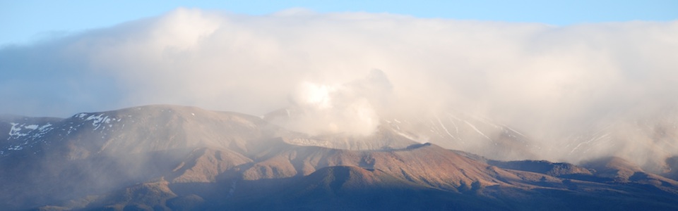
Tongariro Mt Doom 
‘Lord of the Rings’ Landscapes
Tongariro Traverse Track
Take a hike through the Mt Tongariro Mt Doom (Mt Ngauruhoe) ‘Mordor’ like landscapes, from Peter Jackson’s The Lord of the Rings movies. At the end of the walk, visit the DOC Tongariro National Park Visitors Center to learn about the history of the park, or the Chateau Tongariro for a drink or bite to eat. In poor weather the Tongariro Traverse is an excellent alternative day walk at lower altitude than the Tongariro Alpine Crossing.
Another more strenuous option is to climb to the Mt Ruapehu Crater Lake. The climb is best done between December and April when there is no snow on the ground, and when part of the route can be accessed by a scenic chairlift ride.
The Knoll Ridge Chalet cafe has recently been rebuilt, has won many architectural awards and is open daily. Guided walks to the crater lake are also available. The Meads Wall walk (30 minutes) – a Lord of the Rings film location, is an easier option.
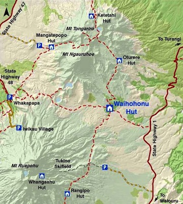
The Tongariro Traverse 
Time: 7-9 hours
Distance: 20 km (one way)
Grade: Easy-Moderate
Begin: SH1 roadside just south of Rangipo Intake Rd., 30min drive south of Turangi
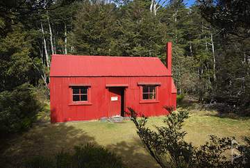
Waihohonu Hut
This is a full-day self-guided hike that traverses the Tongariro National Park from the extreme eastern boundary (700m) to Whakapapa Village, passing between the peaks of Mt Ngauruhoe (2287m) and Mt Ruapehu. This area of the Park is less susceptible to the severe weather conditions that can be experienced at high altitude on the Tongariro Alpine Crossing – making it safer in marginal weather. During the winter season, ice axe and cramp-ons are not required.
Track Description
From SH1 the track follows the stream as it gently climbs to the the Tama Saddle, where the track branches right to Tama Lakes. The lower lake is a 10min side trip from the junction while the upper lake is along a steep ridge.
Whakapapa village is two hours from the Tama Lakes Junction. At the half way stage you reach the Taranaki Falls loop walk, where you can either continue on the main trail or take the falls track to Whakapapa Village.
1 Desert Road to Waihohonu Hut
Distance: 5.6km
Time: 1.5hr
Begin: SH1, on the eastern border of the Park
An easy gradient following the Ohinepango stream. For an interesting detour take the 800m track (20 min return) to the historic Waihohonu hut.
2 New Waihohonu Hut to Lower Tama Lake
Distance: 7km
Time: 3hr
Follow the Waihohonu Track over a gentle gradient to the toxic Lower Tama Lake which is part of the Tama Lakes walk.
3 Lower Tama to Upper Tama Lookout (optional)
Distance: 1km
Time: 1.5hr (return)
A summer-only side track up the slope and back to Upper Tama Lake (1400m), which is a great vantage point for views and photos.
4 Lower Tama to Taranaki Falls
Distance: 3.5km
Time: 2.5hr
Back on the main track you head west to the Taranaki Falls where water spills 10m over rocky terrain in a very scenic setting.
5 Taranaki Falls to Whakapapa Village
Distance: 3.5km
Time: 2.5hr
The last stage is an easy downward walk to the Whakapapa Village, either following the main route of via the falls loop track.
Learn more…
Mt Ruapehu Crater Lake
Distance: 10km or 4km with use of chairlift
Time: 6 hours without use of chairlift
One of the highlights of the Tongariro National Park is a climb to the Ruapehu crater, from where you can gaze down into the geothermal waters of the crater lake and have equally spectacular views back towards Mt Ngauruhoe and Mt Tongariro.The climb is best done between December and April when there is no snow on the ground, when part of the route can be accessed by a scenic chairlift ride.
- This is a steep and at times demanding climb on a poled route over rough terrain
- Not recommended in winter without mountaineering experience and equipment (such as ice axes and crampons)
The most commonly used early summer route, when there is snow still present in the valleys, is up the left- hand-side of the Knoll Ridge t-bar line continuing up the valley above the last t-bar pylon. At the head of the valley climb up onto the ridge behind Glacier Knob where a narrow foot track zigzags up the face and onto Dome Ridge. Follow along Dome Ridge to Dome Shelter.
The second unmarked route is recommended when most of the snow has disappeared. From the top of the Waterfall Express chairlift travel over to your right past pylons indicating the Knoll Ridge t-bar line and over to Restful Ridge. Stay on Restful Ridge as you climb towards the Crater area. You will go up a series of rises. The terrain is mainly rock. At the top of Restful Ridge, there is a more open face. A narrow foot track zigzags up the face and onto Dome Ridge, follow along Dome Ridge to Dome Shelter.
Meads Wall Walk
Meads Wall is a spectacular volcanic rock formation popular with rock climbers and sightseers. It has more recently become known as the location where parts of The Lord of the Rings trilogy were filmed. Meads Wall is an easy 30 minute walk on a marked trail from the ski fields.